Climbing "Mt. Doom"

You probably already know this (does anyone other than our family actually read this stuff?), but we’re from Colorado. Well, Kelsey’s from Colorado. I just happen to have lived there for 5 years before we set off on this little adventure of ours. Anyway, coming from Colorado, we’ve hiked up steep mountains at high altitude, run our fair share of trails, and gotten our thigh burning in the winter on the slopes of the mountains along the I-70 corridor and beyond . In general, we’d consider ourselves fairly fit and experienced “outdoor day-trippers.” Here in NZ, we’ve completed most of the hikes we’ve done well under the advertised time given to us at trailheads and junctions. That said, we’re here to openly claim that the Tongariro Alpine Crossing was one of, if not the most impressive and challenging day-hikes we’ve ever done – either together or as individuals. The challenging half of that claim might be because we decided to make the 12-mile, 8-hour excursion our first major hike since living out of Bethell. But having done it a second time since then (yes, it was truly that impressive), we’re convinced the challenge was largely due to the ‘strenuous side trip’ that is the Mt Ngauruhoe summit climb. So for anyone looking for a little advice on how to complete a “Crossing” that includes a summit of Ngauruhoe (aka "Mt. Doom" in the Lord of the Rings trilogy) without feeling completely wiped for a day and a half following, do read further.
Notes on Ngauruhoe
As a hike in and of itself, Ngauruhoe is no joke. While NZ’s Dept. of Conservation (their National Park Service) has it listed on their website as a ‘hikable’ trail, there is no actual marked route. No bother, we said. We’ll find our way up. For those that aren’t keen to take the inexperienced blind approach, I think I can speak for our small group (Kelsey, myself, and our friend Erica – another Coloradan as a matter of fact) when I recommend utilizing the rocky ridge toward the left side of the easily discernable old lava flows. Though it will provide you a natural ‘staircase’ to utilize, it’s still a challenging route, but it’s the sturdiest footing you’ll find on the way up.

20 to 30 minutes of that return is the downhill - FYI
One doesn’t have to gain much of the 2,132 feet from base to summit before looking off to the (east) side and being struck by a view of the 30º incline against the backdrop of open sky. Yes, 30º incline. Not only is it steep (actually, that’s being kind – it’s straight up), but the ground beneath you is composed entirely of loose volcanic rock and stone (otherwise known as scree). So, if you’re not an avid fan of the StairMaster or other torturous fitness equipment from the 1980s, you may not enjoy the idea of expending large amounts of energy to go seemingly nowhere. To explain it another way, it was the first hike I’ve ever been on where I admittedly desired hiking poles. They probably would have helped. Also, take note of this gem from the DOC website:
Sturdy hiking boots are essential. Trainers are not suitable - you definitely need ankle support!

30º incline for all 2,132 vertical feet of the Mt Ngauruhoe climb
You definitely do. Actually, I would recommend paying mind to all the DOC’s advice posted on the Nguarahoe page. Things to keep in mind for the hike (climb) up:
Follow the track to the saddle between Ngauruhoe and Tongariro. A signposted, poled route leads to the foot of…Mt Ngauruhoe. From here the route is not marked - it's up to you where you climb.
Be aware of falling rocks dislodged by others above - people have been hit by them before.
Avoid entering the inner crater area, where volcanic fumaroles (steam vents) emit overpowering gases.
Wait, what?! Excuse me?...
Yes, Ngauruhoe is considered an active volcano. If by ‘active’ you mean it last ‘erupted’ in the mid-1970s and had its last significant lava flows in the ‘50s. More gems from the DOC:
Mount Ngauruhoe is an active volcano, and eruptions can happen at any time with no warning.
If you are in the active volcanic hazard zone (on or near Ngauruhoe) when an eruption happens, you could be in danger.
"Could be"? Hmmm… – So you’re sayin’ there’s a chance!

Realizing the climb was worth the view - with energy to spare
To get back to the ascent, volcanic threats aside, lacking a good set of poles not only leaves your calves burning from the ‘two steps forward, one significant slide back’ approach, but it just might leave your mind wondering, “Shit! Will I actually have enough energy to make it to the top?” Or, “Ya knowww – is it even going to be worth it?” I can’t remember ever considering giving up early on a return-route hike before, but I’ll be honest – I considered it this time. If it weren’t for Kelsey’s and our friend Erica’s presence, along with everyone withholding the same internal dialogue, I might have said “good enough,” turned around, and carried on downwards. But no one wants to be a downer, so up we went. Good news. Sitting at the summit, letting the gases from the fumaroles waft in, we learned that the answer to both of the questions above is ‘yes.’
After a break at the summit taking in a sun-drenched view north toward the South Crater, Mt Tongariro, and the rest of “the Crossing,” the descent provided a much more enjoyable traverse of the slope. Naturally, it takes much less time to get down. But if you’re careful enough to keep your balance, you can even add some excitement to the slide down. Perhaps it was the high from the sense of accomplishment, or maybe being on top of a mountain peak reminded me that I missed an entire Northern Hemisphere winter, but I couldn’t help but want there to be snow and a board beneath my feet. This mount’ was made for riding! Even without the snow and gear though, the ‘ride’ down on the ‘escalator of scree’ provided enough thrill. Allow me to reiterate though, you’d need to be careful and balanced in order to make it down unscathed. For back-up, I turn once more to the candor of the DOC:
Take care not to gather too much speed, it is easy to trip and there is a long way to fall - and many sharp rocks to hit!
Now, after the Goo Goo Dolls have stopped playing in your head (“Long Way Down” anyone?), it’s time to carry on to your carpark of choice – as a 19.4km hike from end to end, it’s not a loop or return type of journey, at least not in the same day. On our first excursion, the day of the Ngauruhoe summit, our choice was made ahead of time as we arranged a ride from Erica’s boyfriend, Zac, at the Ketetahi Car Park on the northern end of “the Crossing.” Most people recommend doing the hike in this direction, as typically deteriorating weather during the day can leave Mt Tongariro and Ngauruhoe shrouded in clouds by the time you get to them. It can also get quite windy and chilly up near the peaks, lakes, and craters, so again, best to get through that section on the southwest end of the trail earlier in the day with the sun (if it’s out at all that is).
Speaking of the peaks, lakes, and craters

Blue Lake and the Emerald Lakes from atop an edge of Red Crater
Now as we mentioned, the Tongariro Alpine Crossing was one of the most visually impressive hikes we’ve done. Most of that impression was made between South Crater and Blue Lake, the 1.5 hour section just after the Ngauruhoe off-shoot. In the picture to the right, Blue Lake sits just below the slope in the top left corner. More dramatic though, are the three Emerald Lakes that fill explosion craters not far from the summit of Mt Tongariro. The bright green color is an effect of dissolved minerals from the thermal area of Red Crater, pictured below.

A view into the deep reaches of Red Crater
Indeed, we went back for a second time the following week. One, to get more pictures (the cold air the first time around didn’t agree well with our battery life), but two, to have a go at the peak of Mt. Tongariro. Not as challenging as Ngauruhoe as it’s a much more gradual incline, rather than steep climb, but still very much worth the additional out-and-back trek. As you approach the actual peak, if you angle it right, you can get a great view of Tongariro, Ngauruhoe, and Ruapehu all at once. I would say that anyone looking for a bit of a reprieve from the crowds on the main crossing trail should take the time to do this section. Quick, easy, and stunning – in all the right ways, of course.
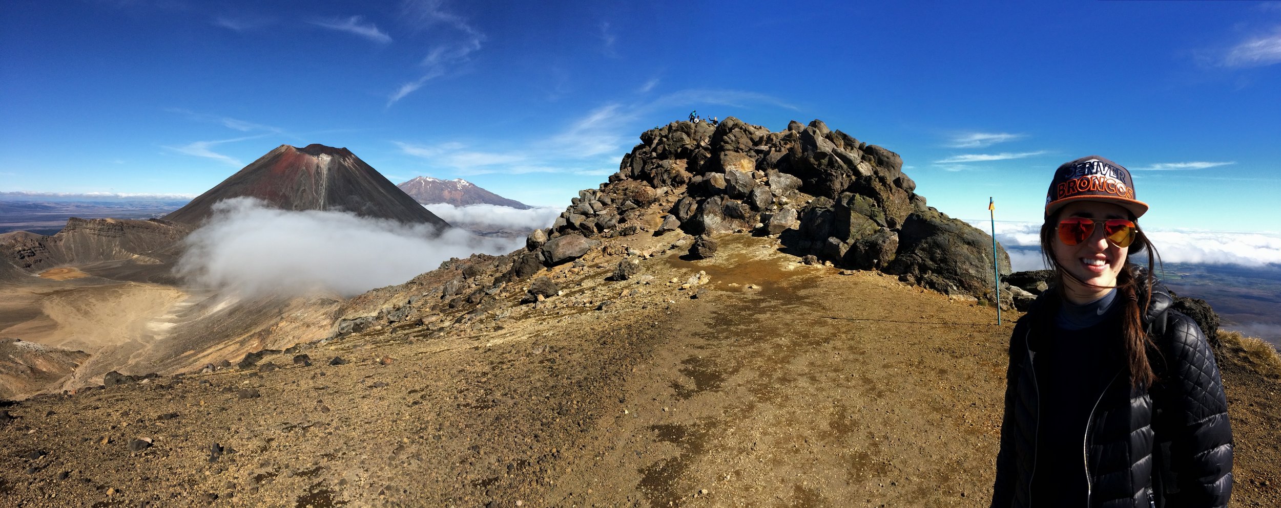
Stunning, from left to right (Ngauruhoe, Ruapehu, Tongariro, Kelsey Nolan)